
Emily B. Osborne1, Xinping Hu2 , Emily R. Hall3, Kimberly Yates4, Jennifer Vreeland-Dawson5, Kathryn Shamberger5, Leticia Barbero1,6, José M Hernández-Ayón7, Fabian Gomez1,8, Tacey Hicks5, Yuanyuan Xu1,6, Melissa R. McCutcheon2, Michael Acquafredda9, Cecilia Chapa-Balcorta10, Orion Norzagaray7, Denis Pierrot1, Alain Munoz-Caravaca11, Kerri L. Dobson9, Nancy Williams12, Nancy N. Rabalais13, Padmanava Dash8, Hauke Kite-Powell14 and Casey Galvin14
(1) NOAA/AOML, Miami, FL, USA (2) Harte Research Institute for Gulf of Mexico Studies, Corpus Christi, TX, USA (3) Mote Marine Laboratory, Sarasota, FL, USA (4) United States Geological Survey, St. Petersburg, FL, USA (5) Texas A&M University, College Station, TX, USA (6) University of Miami, Miami, FL, USA (7) Universidad Autonoma de Baja California, Ensenada, BJ, Mexico (8) Mississippi State University, Starkville, MS, USA (9) NOAA, Silver Spring, MD, USA (10) Universidad del Mar, Puerto Escondido, Oaxaca, Mexico (11) Center for Environmental Studies in Cienfuegos, Cuba (12) University of South Florida, St. Petersburg, FL, USA (13) Louisiana State University, Baton Rouge, LA, USA (14) Woods Hole Oceanographic Institution, Woods Hole, MA, USA
I. Geographical extent of the Gulf of Mexico
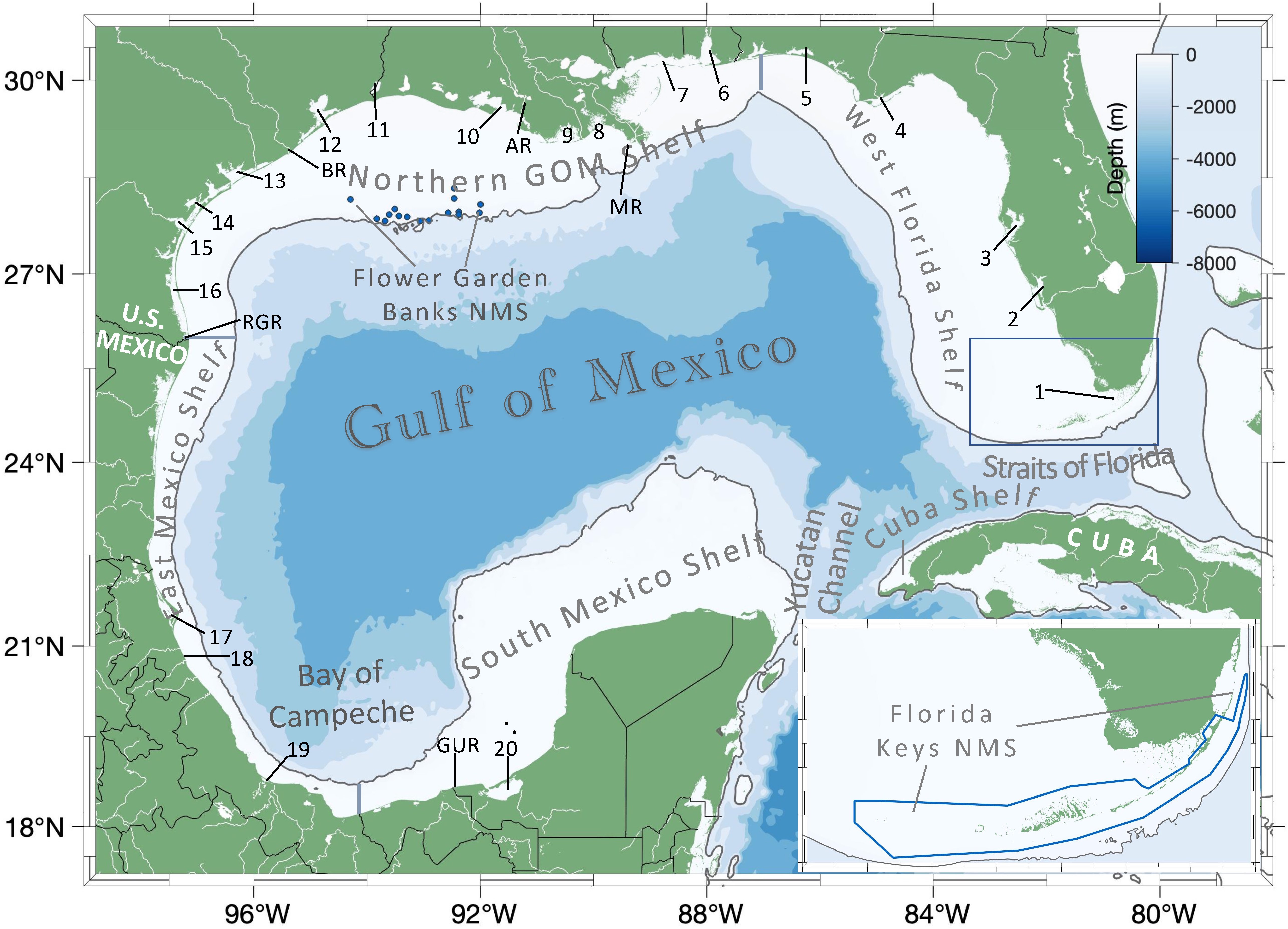
(Hover to enlarge, click to access the full resolution map)
Figure. 1 Map of the GOM identifying major regions examined in this synthesis. The solid gray line represents the 200 m isobath, defined as the boundary between the coastal continental shelf region and open GOM regions. The continental shelves are broken down geographically and are described in detail within Section 2.2. Selected major rivers, bays, and estuaries are identified as follows: MR-Mississippi River, AR-Atchafalaya River, BR-Brazos River, RGR-Rio Grande River, GUR-Grijalva-Usumacinta River; Estuaries: 1-Florida Bay 2-Charlotte Harbor, 3-Tampa Bay, 4-Apalachicola Bay, 5-Pensacola Bay, 6-Mobile Bay, 7-Mississippi Sound, 8-Barataria Bay, 9-Terrebonne/Timbalier Bays, 10-Atchafalaya/Vermilion Bays, 11-Sabine Lake, 12-Trinity-San Jacinto Estuary (Galveston Bay), 13-Colorado-Lavaca Estuary (Matagorda Bay), 14-Mission-Aransas Estuary, 15-Nueces Estuary (Corpus Christi Bay), 16-Laguna Madre (including both the upper and lower portions and Baffin Bay), 17-Laguna de Tamiahua, 18-Laguna de Tuxpan, 19-Laguna de Alvarado 20-Laguna de Terminos. The extents of the two US national marine sanctuaries (NMS), Flower Garden Banks (dark blue dots) and Florida Keys (dark blue box and inset map), are also shown. The maps on this page (expcept Fig. 2) were created using the MatLab routine M_Map.
2. Modeled results
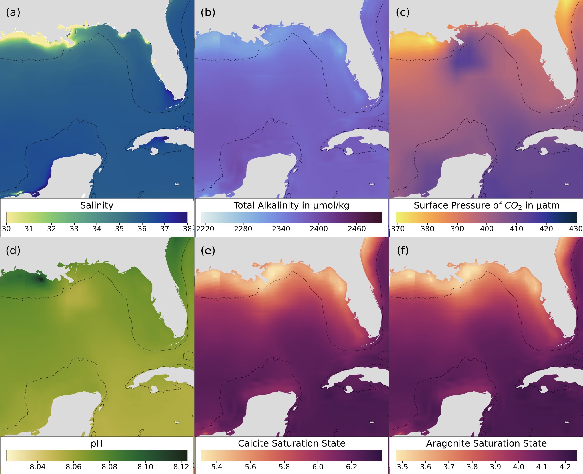
(Hover to enlarge, click to access the full resolution map)
Figure 2. Modelled mean (2014-2020) GOM surface values of (a) HYCOM salinity, (b) total alkalinity (µmol/kg), (c) partial pressure of CO2 (pCO2, µatm), (d) pH, (e) calcite saturation state, and (f) aragonite saturation state. Carbonate system parameters presented were produced by calculating the average of the datasets created by the NOAA/AOML ACCRETE (Acidification, Climate, and Coral Reef Ecosystems Team; https://www.coral.noaa.gov/accrete/oaps.html; downloaded the dataset on June 12th 2021). The western Gulf coast is excluded from this analysis because ACCRETE does not calculate values for the region. The black lines indicate 200 m isobath. Map colorbars were created following Thyng et al. (2016).
Top3. GOM ocean acidification data
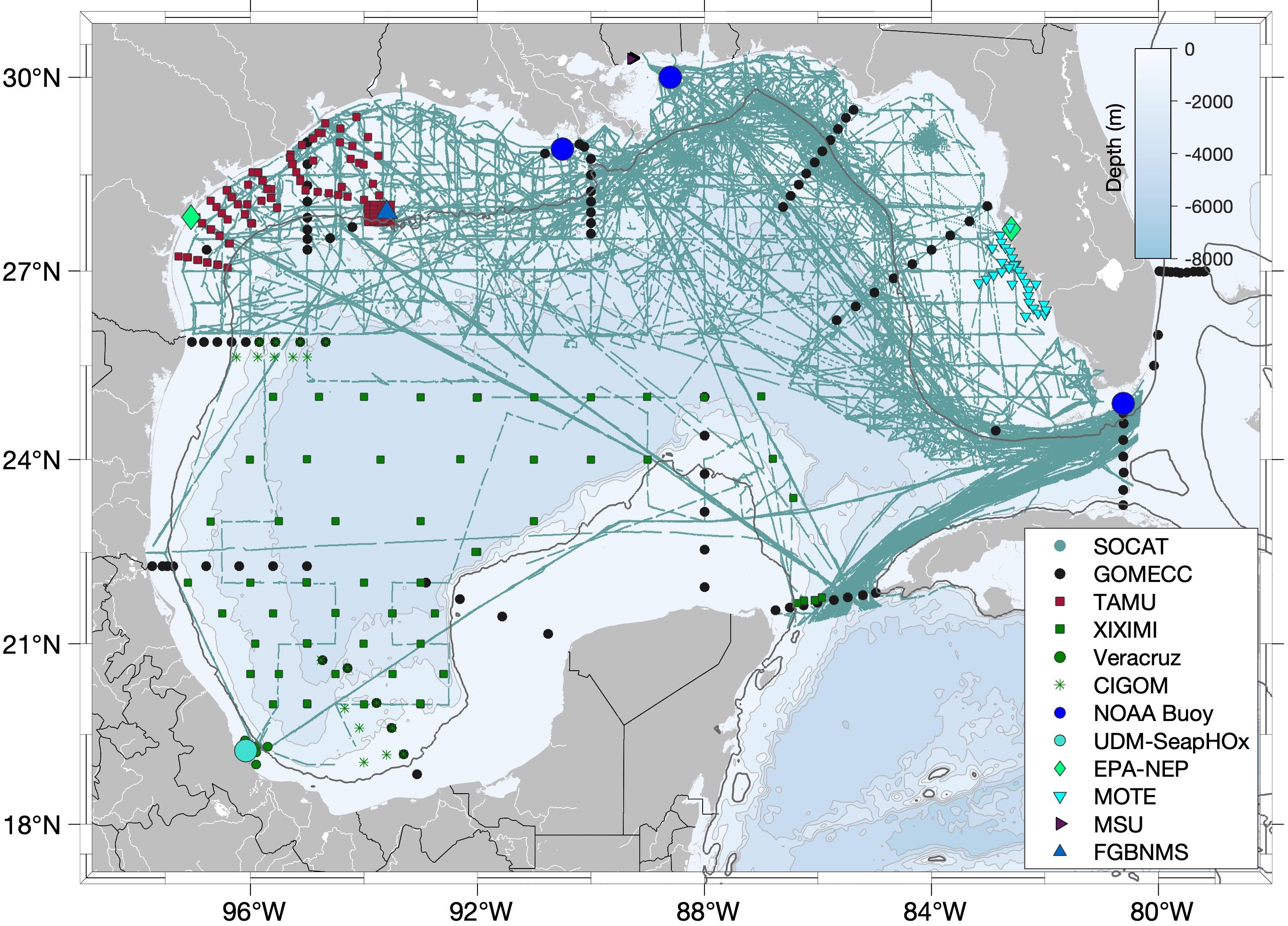
(Hover to enlarge, click to access the full resolution map)
Dataset |
Data Type |
GOM Region |
Source and Contact |
Discrete water column DIC, TA, pH, pCO2, CO3,DO, nutrients, chl and surface pCO2, |
Gulf wide |
US NOAA/AOML L. Barbero |
|
Surface pCO2 |
Gulf wide |
US NOAA/AOML D. Pierrot |
|
Satellite data assimilation |
Eastern GOM and Caribbean |
US NOAA/AOML R. Van Hooidonk |
|
nGOMx Acidification (2017 2018 2019) |
Discrete water column DIC, TA, pH, DO and |
Northern GOM Shelf |
US University of Delaware W.-J. Cai |
Surface pCO2 |
Northern GOM Shelf |
US University of Delaware W.-J. Cai |
|
Bottom water DIC and TA |
Northern GOM Shelf |
US University of Delaware W.-J. Cai |
|
nGOMx Shelfwide Hypoxia Cruise (2010, 2011, 2012, 2013, 2014, 2015, 2016) |
Discrete water column DIC, TA, pH |
Northern GOM Shelf |
US Texas A&M-CC X. Hu |
Surface and atmospheric CO2 and surface water pH |
Northern GOM Shelf |
US NOAA/PMEL A. Sutton |
|
Surface and atmospheric CO2 and surface water pH |
Northern GOM Shelf |
US NOAA/PMEL A. Sutton |
|
Surface and atmospheric CO2 and surface water pH |
Florida Shelf (Florida Keys National Marine Sanctuary) |
US NOAA/PMEL A. Sutton |
|
Tampa Bay Estuary and Eastern Gulf of Mexico (2018-present) |
Real time pH, surface pCO2, DO; discrete mid-water column TA, DIC, pH |
Florida West Coast Estuary and West Florida Shelf |
US USGS K. Yates |
Surface pH and pCO2 |
Port Aransas Ship Channel, Texas, |
US Texas A&M-CC X. Hu |
|
Discrete water column TA, DIC, pH |
Texas Estuaries |
US Texas A&M-CC X. Hu |
|
Discrete water column TA, DIC, pH |
Texas Estuaries |
US Texas A&M-CC X. Hu |
|
Discrete water column TA, DIC, pH |
Northern GOM Shelf (Flower Garden Banks) |
US Texas A&M-CC X. Hu |
|
TAMU Galveston Bay Cruises (2017-2019) |
Discrete water column TA, DIC, dissolved inorganic nutrients, DO |
Estuary (Galveston Bay, Texas) |
US Texas A&M K.E.F. Shamberger |
Discrete water column TA, DIC, dissolved inorganic nutrients, DO |
Northern GOM Shelf (Texas Shelf and Flower Garden Banks) |
US Texas A&M K.E.F. Shamberger |
|
Mote Marine Lab Sampling (2019-present) |
Discrete water column TA, DIC, pH, nutrients (dissolved, particulate, total), phytoplankton community, toxins |
West Florida Shelf and Estuaries |
US Mote Marine Laboratory E. Hall |
XIXIMI Cruises (2010 2011 2013 2015 2016 2017) |
Discrete water column TA, DIC, pH, nutrients, phytoplankton |
Open GOM and Bay of Campeche |
Mexico University of Baja California J.M. Hernández-Ayon |
Mississippi Based RESTORE Act Center of Excellence (MBRACE) Sampling (2018-present) |
Discrete water column TA, DIC, pH, DO, nutrients, phytoplankton community structure, Chl-a, Phycocyanin, toxins |
Northern GOM Shelf (Mississippi Sound over the natural oyster reefs) |
US Mississippi State University P. Dash |
Veracruz Reef System National Park stations (2018 2020) |
Discrete water column temperature, salinity, pH, AT, DIC |
East Mexico Shelf |
Mexico Universidad del Mar/Universidad Veracruzana C. Chapa Balcorta |
Veracruz SeapHOX monitoring station (2019-2021) |
20 m depth temperature, salinity, oxygen, pH |
East Mexico Shelf |
Mexico Universidad del Mar and Universidad Veracruzana C. Chapa Balcorta |
Malla Fina Campaign, CIGOM project (March and September 2016) |
Discrete water column TA, DIC, pH |
East and South Mexico Shelf |
Mexico, University of Baja California O. Norzagaray |
Cuba OA Monitoring Stations (2020-present) |
pH and TA |
Cuba Shelf |
Cuba A.Munoz-Caravaca |
4. GOM habitats
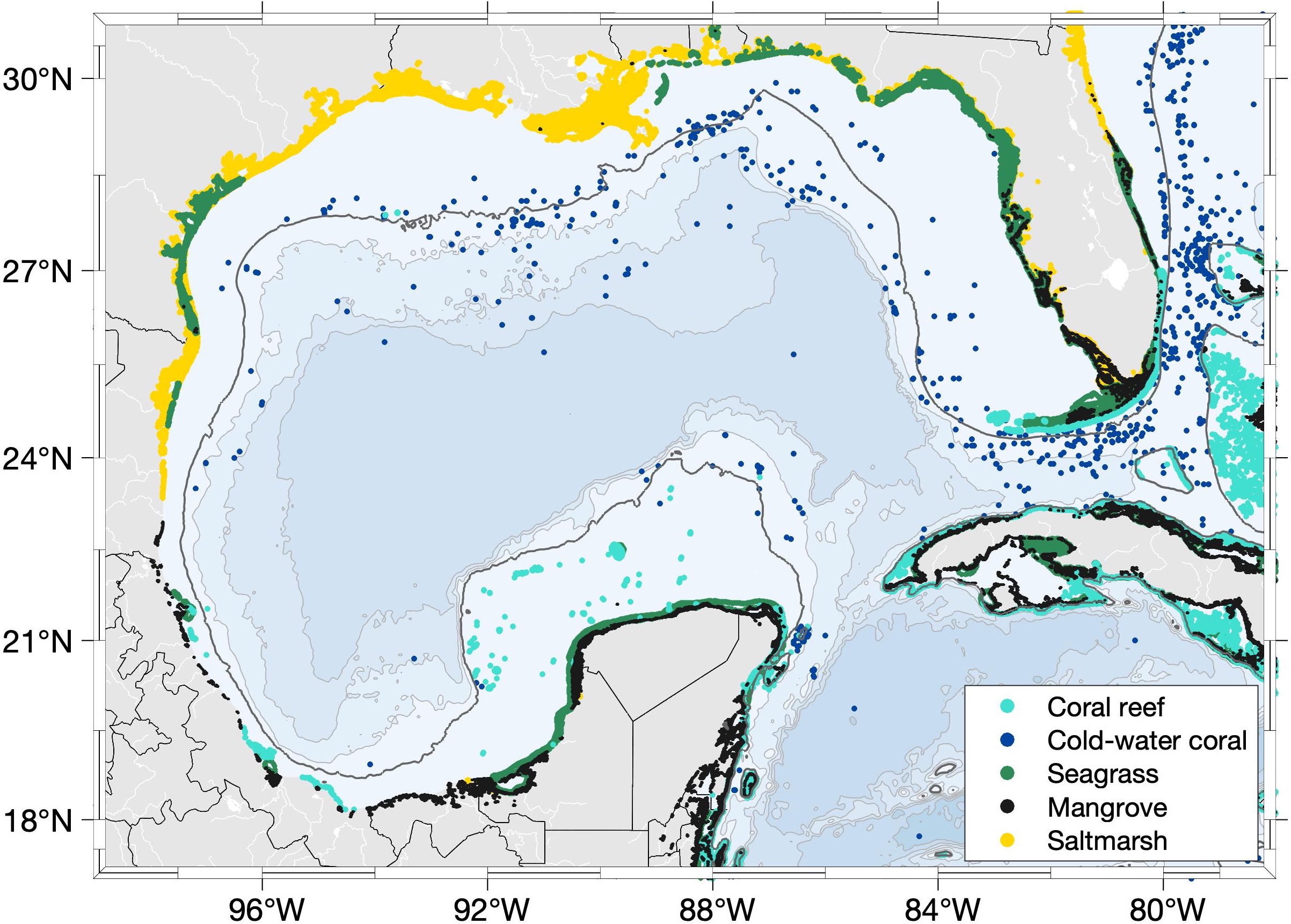
Figure 4. Distribution of salt marsh (yellow), seagrass (green), mangroves (black), shallow coral reefs (cyan) and cold water corals (blue) in the Gulf of Mexico. Habitat data are from the UN Environment Programme World Conservation Monitoring Centre (https://data.unep-wcmc.org/, (UNEP-WCMC and Short 2020, Freiwald et al. 2017, UNEP-WCMC et al. 2010, Spalding et al. 2010, McCowen et al. 2017).The dark gray bathymetry contour represents the 200 m isobath. Light grey bathymetry lines represent 1000 2000, and 3000 m depths, respectively.
Top5. Biological responses
Species |
Response |
References |
| Oysters (Crassostrea virginica) | 1, 2, 3, 4, 5, 6, 7, 8 | |
| Bay scallop (Argopecten irradians) | 1, 2 | |
| Hard clam (Mercenaria spp) | 1, 2 | |
| Queen conch (Strombus gigas) | 1 | |
| Gulf shrimp | 1, 2, 3 | |
| Stone crab | 1, 2, 3 | |
| Blue Crab | 1 | |
| Spiny lobser | 1 | |
| Finfish | 1, 2 | |
| Corals | 1, 2, 3, 4 | |
| Deep-sea corals | 1, 2, 3, 4, 5, 6, 7 | |
| Sponges | 1, 2, 3, 4, 5, 6 | |
| Sea urchins | 1, 2, 3, 4 | |
| Habitats | ||
| Seagrass beds | 1, 2, 3, 4, 5, 6, 7, 8, 9, 10, 11, 12, 13, 14, 15, 16, 17, 18 | |
| Mangroves | 1, 2, 3, 4, 5, 6, 7, 8, 9, 10, 11, 12, 13, 14, 15 | |
| Salt marshes | 1, 2, 3 | |
| Coral reefs | 1, 2, 3, 4, 5, 6, 7, 8, 9, 10, 11, 12, 13, 14 | |
| Oyster reefs | 1, 2 |
| Response | Sign |
| Negative | |
| Unknown/Negative | |
| Neutral/Positive | |
| Neutral/Negative |
6. GCAN GOM OA monitoring and research gaps
GOM OA Monitoring Gaps
The GOM lacks sustained observing assets in the open ocean, coastal zones, and estuaries needed to fill major data gaps that are critical to tracking the progression and understanding the dynamics of acidification. Observations need to include, at minimum, two of the four carbonate system variables (pH, pCO2, DIC, TA).
Open ocean observing
Coastal zone observing
Estuarine observing
GOM OA Research Gaps
There are considerable knowledge gaps with respect to the dynamics, regional, and sub-regional impacts of OA in the GOM. Regionally-focused, hypothesis-driven research on GOM marine ecosystems, physical-chemical dynamics, and multi-stressor interactions is central to building a more robust scientific understanding of OA within the GOM.
Synthesizing existing OA-relevant data
Improving near- and long-term regional and sub-regional projections
Modeling studies are required to improve the representation of carbon system dynamics and gain further insights on the carbonate system variability. Improvement in future modeling efforts are
Advancing ocean observing technologies
Generating paleo-records to extend the observational record
Understanding drivers and environmental influences
Response of ecologically and economically important marine species
Impacts to ecosystems and ecosystem services
Socioeconomic impacts
7. Next steps
Results from this synthesis will be used by GCAN to guide outreach and communication activities for informing the broader community on the state of OA knowledge in the GOM, and to initiate synthesis and examination of relevant socioeconomic data and information for identifying potential human and ecosystem risks and vulnerabilities.
Acknowledgements
The Gulf of Mexico Coastal Acidification Network (GCAN) initiated this synthesis, facilitated the collaborative process that led to this manuscript, and provided funding for its publication. GCAN is supported by NOAA’s Integrated Ocean Observing Program (IOOS), Gulf of Mexico Coastal Ocean Observing System (GCOOS), and NOAA Ocean Acidification Program. This research was carried out in part under the auspices of the Cooperative Institute for Marine and Atmospheric Studies (CIMAS) (EMO, LB, and YX), a Cooperative Institute of the University of Miami and the National Oceanic and Atmospheric Administration, cooperative agreement # NA20OAR4320472. XH was supported by NOAA’s Ocean Acidification Program (grant #. NA19OAR0170354) and NSF Chemical Oceanography Program (grant #. OCE-1654232). ERH was supported by State of Florida, Florida Fish and Wildlife Conservation Commission (cooperative agreement #20034) and SECOORA Agreement #IOOS.16(028)MOTE.EH.OA.5 under NOAA IOOS (award #NA16NOS0120028). KEFS was supported by NSF Division of Ocean Sciences (grants #1800913 and #1760381); EPA Gulf of Mexico Cooperative Agreement #12461398; and the Department of Oceanography, College of Geosciences, and T3: Texas A&M Triads for Transformation at Texas A&M University. TLH was supported by NSF S-STEM (grant #1355807); NOAA Texas Sea Grant Grants-In-Aid of Graduate Research Program; and the College of Geosciences Graduate Merit Fellowship and Department of Oceanography at Texas A&M University. JMHA was funded by the Mexican National Council for Science and Technology - Mexican Ministry of Energy - Hydrocarbon Fund [project 201441]. This is a contribution of the Gulf of Mexico Research Consortium (CIGoM). JMHA acknowledge PEMEX’s specific request to the Hydrocarbon Fund to address the environmental effects of oil spills in the Gulf of Mexico. AMC acknowledges support from Centro de Estudios Ambientales de Cienfuegos, Cuba. NLW was supported by the University of South Florida. FG was supported by the NOAA Ocean Acidification Program and the NOAA Climate Program Office Modeling, Analysis, Predictions, and Projections (MAPP) program.